Mount Fury
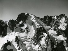
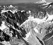
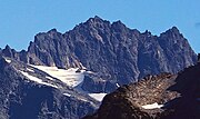
Mountain in Washington (state), United StatesMount Fury, elevation 8,356+ ft, is in North Cascades National Park in the U.S. state of Washington. Several small glaciers are on the slopes of Mount Fury, and it is the highest peak in the Picket Range. A theodolite survey of West and East Fury on Oct 22, 2022, established the altitudes of the two peaks of Fury. West Fury was set at 8,305ft +/-10 feet and East Fury as 8,356 +/- 8ft. This makes East Fury one of the 100 highest peaks in the State of Washington. Luna is now the second highest peak in the Picket Range.
Read article
_in_base_of_Luna_Cirque_North_Cascades_Nat._Park_Picket_Range_North_Cascades,_WA.jpg)


Top Questions
AI generatedMore questions
Nearby Places

North Cascades National Park
National Park in Washington, United States
Mount Challenger (Washington)
Mountain in Washington (state), United States
Luna Lake (Washington)
Glacial Lake in Washington, United States
Phantom Peak
Mountain in Washington (state), United States
Crooked Thumb Peak
Mountain in Washington (state), United States
Ghost Peak
Mountain in Washington (state), United States
Poltergeist Pinnacle
Mountain in Washington (state), United States

Mount Crowder (Washington)
Mountain in Washington (state), United States